NSF Awards: 1614216
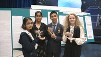
This ITEST project has developed, implemented, and evaluated a series of innovative socio-environmental science investigations (SESI) using a geospatial curriculum approach that has provided economically disadvantaged students in the 9th grade of the Building 21 school in Allentown, PA with technology-rich geospatial learning experiences to develop STEM-related skills. SESI focus on social issues related to environmental science. These issues are multi-disciplinary, involve decision-making that is based on the analysis of scientific data connected to relevant social science content, and has implications for social equity. This project used a design partnership between Lehigh University natural science professors, social science professors, education professors, Building 21 science and social studies school teachers, and STEM professionals in the local community to develop geospatial investigations with Web GIS that are designed to prepare students with skills, and career awareness, to motivate them to pursue appropriate education pathways for STEM-related occupations. The learning activities provide opportunities for students to collaborate, seek evidence, problem-solve, master technology, develop geospatial thinking and reasoning skills, and practice communication skills that are essential for the STEM workplace.
This project attends to a significant challenge in STEM education: the recognized deficiency in quality locally-based and relevant high school curriculum for under-represented students that focuses on local social issues related to the environment. Environmental issues have great societal relevance and because many environmental problems have a disproportionate impact on underrepresented and disadvantaged groups, they provide a compelling subject of study for students from these groups in developing STEM-related skills.


Kate Popejoy
Owner
Thank you for watching our video that highlights our socio-environmental science investigations. We are finishing the second year of our project and have just completed the pilot-testing of the investigations at the Building 21 High School in Allentown, PA.
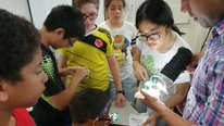
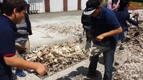
The video showcases some of the mobile data collection and Web GIS analysis learning activities.
Think about the following questions and share your thoughts:
In what ways do these learning opportunities promote STEM-related skills and exposure to workforce readiness skills?
Can you identify some school-level characteristics of the Building 21 High School that create unique opportunities for urban students to study their local environment?
Can you envision your local high school engaging these types of investigations? Why or why not?
Robson Junior
Courtney Tanenbaum
Principal Researcher
I really liked how you discussed some of the challenges in recruiting mentors for the project. What strategies were most effective in overcoming these challenges? Did you learn any important lessons about recruiting mentors that could inform the work of others? Also, how easy or difficult was it to incorporate this type of technology into the learning environment? Did teachers need special training and/or did you need to work with the schools to fit these types of activities into the curriculum? Finally, are there any results from the pilot that you can share?
Robson Junior
Kate Popejoy
Owner
These are all very good questions! For now, I will address the mentor questions...
Recruiting mentors is a challenge, though there are ways to succeed. First, we obtained specific letters of commitment from our two most prominent mentor sources, PPL and the city of Allentown, at the proposal level. I personally met with people at PPL and the City before we got those letters. I had a pretty good idea about specific people within each organization who would be most interested in this work via this process.
When we got funded, and it came time to recruit the actual mentors, we had written commitments. This helped for PPL as my contacts there recruited within their organization for me. We were able to recruit three people from PPL.
However, the City of Allentown was going through political turmoil as the mayor had been indicted on federal charges. (He has since been found guilty.). I was asked to delay my recruitment of city workers for a year. But, once I got in the door, I was able to recruit their GIS office people, a Zoning Officer (featured in our video!), and also someone from public works.
This personalization of mentor recruitment is what worked for us. We needed to establish relationships with each person to get them "hooked" into our project. We then needed to work with their schedules to get them into the classroom to work with students (via a Google sheet). This required lots of patience and perseverance. For example, our arborist from PPL was unable to work with students this past Fall as he was in Florida for many weeks helping with hurricane recovery.
To sum up, yes, mentors can be recruited for projects like this. However, large numbers are challenging. Cultivate relationships with individuals, make them feel welcome, give them appropriate training, and spend time with mentors!
Robson Junior
Shannon Salter
Hi Courtney,
As one of the instructors I can speak to the technology integration. Thankfully, the grant afforded us the ability for a great deal of PD so that I and my fellow instructors could learn the technology, which then enabled us to turn around and support the students. Having mentors on the team who were skilled in the GIS was important, because as students were taking their first steps with the technology we had more hands on deck to help support them. We have worked with the research team every step of the way to fit these investigations into the scope and sequence of our curriculum - both in science and in social studies - and that is definitely a work in progress that takes a few tries to get right. I'm a firm believer in making sure technology serves the learning goals, not vice versa. This level of GIS is definitely not plug-n-play, so teachers interested in bringing this tool into their classroom need to be prepared to give some time to technology instruction - both for themselves, and then for their students. The good news is that we were able to create some engaging, scavenger-hunt-like activities to teach students the tools.
Kate Popejoy
Courtney Tanenbaum
Robson Junior
Alec Bodzin
Professor
Hi Courtney.
We used a hybrid professional development (PD) model that includes both face-to-face and online learning activities to promote teacher geospatial pedagogical content knowledge. Additional information about this can be found in this publication:
Hammond, T.C., Bodzin, A., Anastasio, D., Holland, B., Popejoy, K., Sahagian, D., Rutzmoser, S., Carrigan, J., & Farina, W. (2018). “You know you can do this, right?”: Developing geospatial technological pedagogical content knowledge (GS-TPACK) and enhancing teachers’ cartographic behaviors with Socio-Environmental Science Investigations (SESI). Cartography and Geographic Information Science, 45(4), 305-318.
We are pilot-testing the SESI investigations this year and and are gathering our posttest data at this time.
Robson Junior
Courtney Tanenbaum
Courtney Tanenbaum
Principal Researcher
Thank you for sharing these helpful resources! And, for all of the above comments explaining in more detail how you built rapport, developed relationships, and gained commitment from key stakeholders. The insights into the PD from Shannon's perspective highlight how beneficial a close researcher-practitioner relationship can be! I'd love to hear more from the researcher's side about the benefits of this close research/practice relationship.
Robson Junior
Tom Hammond
Associate Professor
Courtney: Others may wish to chime in here, but part of my reaction is what I previously posted (see my response to a question from Melissa Demetrikopoulos elsewhere in this forum): working with teachers extends the imaginative reach of the researchers, allowing us to grasp the disciplinary structures that they're working in or the specific needs of their student community. Doing design and development work WITHOUT teacher-collaborators is, in my view, not a good idea. The classroom is a very constrained ecology, with multiple conflicting pressures (for example: covering the curriculum vs. assessment of student learning vs. administrative tasks). Teachers can navigate this ecology better than university folks, even those of us who logged previous decades as classroom teachers. When I work with in-service teachers, I have much more faith in the final products, both as an instructional product AND as a research finding.
Robson Junior
Barbara Berns
Education Planner
I loved seeing this video about Allentown because I visited that city a lot as a child growing up in Scranton, PA!
The students' reaction to using technology was very positive, and they are definitely learning a skill (as well as content) that will serve them well. It was great hearing that teachers also are learning a lot too. Any evaluation data yet?
I had a bit of difficulty understanding the actual content related to learning how the ecosystem works. Could you please say more about the comment related to the students thinking about what they want Allentown to be like in the future?
Robson Junior
Shannon Salter
Hi Barbara,
As a social studies educator, my favorite thing about this project is how it helps students take content from one area (environmental science) and turn it into a tool for thinking about their community and how they'd shape that community in the future. Students use the collection tool to study concepts they've learned in science class - for example, taking temperature readings, or observing tree coverage - and then looking at how they might apply what they've learned to support proposals for resources they'd like added to their neighborhoods in the future (how will they protect the environment while adding new sources of recreation, or create jobs? How can they reuse vacant and/or abandoned sites within the city to better meet human needs without increasing the urban heat island effect? How can they create bike paths or opportunities to reduce the carbon emissions that come from our transportation choices?)
In short, we're teaching them about the role of urban planning in ensuring our cities grow in smart ways, rather than experiencing the negative effects of urban sprawl.
Kate Popejoy
Robson Junior
Alec Bodzin
Professor
Hi Barbara.
We have great feedback from our external program evaluators that have told us that we are on the right track with our design and development work, our professional development approach (see CaGIS article posted elsewhere in thread) and with the optimization of our data collection instrumentation that we piloted in year one.
No research data yet. We are finishing up pilot-testing this school year and will be field-testing next year.
Robson Junior
Cary Chadwick
I think it's fantastic that you are introducing students to GIS. What challenges, if any, did you encounter with working with Esri's Collector and ArcGIS Online? How much detail did you go into with the students? Did they create the geospatial data schema or were they just using the mobile devices to collect field data? Sometimes I find it is easy to showcase the button pressing but more challenging to teach the underlying technology, especially with limited time. If you have any suggestions, I'd love to hear! Also, how long was the teaching time-period? Day, week, semester? Thanks!
Robson Junior
Shannon Salter
Hi Cary.
As it is their first use of GIS, students used a combination of data they collected in the field and data layers that we created/found for them. We have not yet had them go so far as to create the geospatial data layers themselves. It is my hope that in future years (these students are freshmen) that our colleagues will leverage these students growing skills and take them farther with the tool. Bringing other teachers up to speed in ArcGIS is a focus of our summer PD this year.
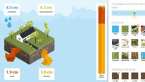
Students used ArcGIS for a total of 6 investigations and 3 projects this year, spread throughout the school year. We also built in some introductory GIS-supported scavenger hunts in the beginning of the year to help introduce them to the tech. During our investigations, our classes operate in block schedules - 90 minutes 4 days a week plus one 45 minute period on the 5th day. Having that extended time is definitely a bonus, especially on data collection days.
I'd say the students have become fairly skilled at manipulating data layers, using map notes to annotate their maps and prepare them for use in their own projects, and using the measuring tools and data tables (sorting, filtering) to get the most of the data in front of them. Hopefully in later years they'll be able to go further and source their own data.
Kate Popejoy
Robson Junior
Alec Bodzin
Professor
Hi Cary.
In our first year of the project - prototype testing - we learned it took students a bit of time to login with an assigned ID and password, learn how to download maps to the Collector app and set the data collection area. It also took some students some time during the first and second investigations to get use to using the ArcGIS online tool suite - drawing on maps, querying, etc. No issue with the actual data collection. We purposefully set the data collection fields to be intuitive with many drop-down selections when possible. We also set the initial ArcGIS.com data displays to hep make geospatial relationships more readily apparent.
From the learning experience, we decided it would be in our best interest to develop 2 scavenger hunt activities to get used to these interfaces and activities. We implemented this during the weeks 2 and 3 of the school year and it worked well. These were each 2-day learning activities. By the time we got to the first investigation, students were up and running quickly with little downtime on GIS-related procedural tasks.
Robson Junior
Shannon Salter
Hello Everyone! I am one of the two primary instructors at Building 21 for this curriculum. As a social studies teacher, my primary focus during this project is helping students use the skills of social science - such as geography - to take their learning from other content areas and translate it into the basis of civic action in their communities. This project has allowed our students to place the concepts they've learned in environmental science and use them to inform their ideas about how to better grow the city of Allentown in the future. The students use the data that they explore through ArcGIS - both data they've collected and data layers we've helped them to import - to make cases for the changes they'd like to see in their community. Thank you for taking the time to look at our work, and I look forward to answering your questions!
Kate Popejoy
Robson Junior
Benjamin Walters
Hello! I think it is great how your project uses technical tools to give students an opportunity to venture outside of the classroom and practice real-world applications as part of the curriculum. I was wondering how active the students are in deciding what they are going to investigate? Do students get to choose which type of data they want to collect? If so, what resources do you use to guide them in this process? Can you share some of the most inventive projects/results that students came up with? Thanks for sharing your project!
Robson Junior
Shannon Salter
Student choice is vital to sustaining their engagement. We created increasing opportunities for choice as the year went on - at the beginning of the year they were given very narrow parameters (explore the school property and use the GIS to make the case for a location to plant new trees). By the end-of-year culminating project, students were given their choice of a Ward within the city of Allentown, and told to make one recommendation of an addition to the built environment that would provide an opportunity for growth in a way with environmental, social, and economic benefits. Students had freedom over the ideas they brought forth and the data they used to make their case.
These culminating projects are being wrapped up as I type, but I can tell you I've seen some very inventive proposals - I'm currently reading about a gym that allows you to was your clothes in a laundromat while you work out.
One of the crucial elements to keeping student interest is making the real-world applications real. The tree planting proposal I mentioned? Our school district, with the support of the City's Shade Tree Commission, has committed to selecting one student proposal and following through with an actual tree planting. Students will see the results of their learning in the real world.
Kate Popejoy
Robson Junior
Benjamin Walters
Kevin Floyd
I love the commitments to implement one of the student proposals! That extra connection to the real world should really help motivate the students (and teachers) with their projects. Knowing that what they are doing is bigger than another class project is great. Very cool project, and I look forward to learning more about it.
Kevin
Robson Junior
Robson Junior
Hi there!
I am one of the Research Assistants of the project implementation. Currently, I am enrolled in the Ph.D. program of Teaching, Learning, and Technology at Lehigh University College of Education. My role as an RA is to serve as a mentor/facilitator of students' usage of the new technology, and to assist with data collection procedures (e.g., administering surveys, and data entry).
Thank you!
Gustavo Ribeiro Sacramento Strauss
Barbara Berns
Education Planner
I'm back to thinking about the science-social studies connections. Prior to this project, had any of the participating science teachers used science curriculum? Was it a hard sell? I'm also curious about how you developed buy-in from the social studies department.
Robson Junior
Shannon Salter
As the social studies teacher in question, I can give you my two cents. You're right...science and social studies have a history of behaving like the Sharks and the Jets in secondary ed. It requires a mindset change for some social studies teachers to open their doors (and minds!) to science, and for science teachers to connect their work to civics. Some teachers who are new to this mindset have a bit of a "you got your peanut butter on my chocolate!" reaction at first.
In our case, I've always included the impact of scientific discovery on history and politics in my teaching, so it wasn't a stretch at all. I have questions about any social studies teacher who hasn't - and upon reflection, most realize they have. This combination is also a great opportunity for teachers to model the practices of lifelong learners: I'm not shy about letting students know that the science is new to me, and sometimes we have to call out to my scientific partner in crime for help.
I think there is shared frustration within social studies teachers that students - and even educational institutions - don't always see the relevance of our subject area. By empowering social studies to be the link between any learning and the outside world, we create a new, powerful context for the skills we teach. It has been my experience that most social studies teachers can buy in to that.
btw - the buy-in goes both ways. A feather in my personal cap is that at a mid-year PD, when I challenged our building teacher to declare the one enduring understanding that they want students to have retained 5 years from now, my science partner's answer was "how science can be the basis of decision making in our communities." Social Studies goals for the win!
Kate Popejoy
Robson Junior
Courtney Tanenbaum
Tom Hammond
Associate Professor
Shannon's response got me thinking about the history of social studies as being a content area that is sometimes yoked to another part of the curriculum. Case in point: Humanities-driven curricula, in which history and language arts are taught in either a unified course or as linked courses. (Consider, as an example: reading The Red Badge of Courage in English class at the same time as covering the Civil War unit in history class, perhaps with crossover assignments between the two teachers.) The concept of a humanities curriculum has the force of tradition behind it--a classical education, after all, was humanities-focused--and is reinforced in the No Child Left Behind Era as an opportunity to enlist social studies as a means to boost students' reading and writing scores.
Our experience suggests that social studies and science make a very natural pairing, particularly when focused on geospatial inquiry.
Robson Junior
Tom Hammond
Associate Professor
Barbara: You've hit upon a very, VERY interesting topic for our work! At the start of project, we were operating on a pretty simple, opportunistic premise: There's lots of geospatial integration work in science, there's also some in social studies; why not put them together into one project? We assumed that students' experiences would be more powerful if they were getting it in two content areas and not just one. (It also helped that we have a science/social studies duality going on within the grant team -- Dr. Bodzin has a long track record in science and environmental education, while I am a social studies professor.) As long as we figured out the points at which the curricular activities have to diverge (a carbon sequestration lab, for example, is done only in the science classes) and where they should converge (trees & environmental services spans both content areas), we were good to go--two parallel, interacting curricula, both with geospatial investigation activities, mentors, and the whole nine yards. In this view, working in two content areas rather than one was basically a way to double the dosage, so to speak.
Once we got started in the grant, however, we came to realize that there's something important about the cross-curricular connection. First, the point of these geospatial activities is to connect students to their larger contexts: school, neighborhood, city, region, etc. When you make this same connection-across-contexts in not just one class but in two classes, when it's not just one teacher but two teachers discussing it, it becomes far more real to the students. Spatial thinking and data-driven arguments become ways of seeing the world rather than just things-you-do-in-science class (or social studies class). Second, one of our participating teachers (Shannon--see her comments elsewhere in this discussion) framing a very, very nice rationale for why these two content areas should be addressed in tandem: social studies class is (or should be) about policy and decision-making--what choices should we make as we examine our civic, or national, or global issues. Science class, on the other hand, focuses on how things happen--how do the pieces fit together? How do they interact? When these two content areas work together, then, both are enriched: we can engage in civic thinking that is informed by science (both environmental and social), and we can engage in scientific thinking that is civic-oriented. Of course, it helps that we have such wonderful participating teachers--you need a social studies teacher who is comfortable with and excited about science education and a science teacher who is comfortable with and excited by social studies education. We are super-fortunate to have exactly that!
Thanks for asking the question! It's definitely a topic that we're thinking about as we work!
Robson Junior
Kelly Riedinger
Senior Researcher
Thank you for sharing your video. It was wonderful to see students engaged with technology and scientific investigations. I also appreciated the efforts the project has made to connect with the community and engage community professionals.
Can you tell us more about the research component? What are some of your research questions? What are some of the constructs you are measuring?
I also am curious to learn more about the mentors. Thank you for sharing details about recruitment. Do you provide any support or PD for the mentors to effectively engage with students? Do you measure any outcomes for the mentors as a result of participation?
Robson Junior
Alec Bodzin
Professor
Hi Kelly.This project seeks to address the following primary research questions (RQs):
RQ1. Which program intervention components related to teachers, mentors, and/or students may predict whether or not the intervention students can achieve proficiency in STEM-related skills for geospatial thinking and reasoning (GTR), critical thinking, and communication?
RQ2a. Which program intervention components related to teachers, mentors, and/or students may predict the intervention students’ STEM-related interest at the end of intervention year?
RQ2b. Is there any significant difference in the STEM-related interest at the end of intervention year between students from the intervention group and those from the control group?
RQ3a. Which program intervention components related to teachers, mentors, and/or students may predict the intervention students’ motivation to pursue STEM-related careers at the end of intervention year?
RQ3b. Is there any significant difference in the motivation to pursue STEM-related careers at the end of intervention year between students from the intervention group and those from the control group?
RQ4. How do the STEM mentors perceive their mentoring experience in terms of skill development, connection with youth, and personal satisfaction?
Some of the constructs include spatial learning attitudes, attitudes towards geospatial technology, STEM career interest, and interest in learning science and science-related careers.
We have assembled some online training materials to support the mentors to work with the students. They focus on three categories: pedagogy, classroom management, and interpersonal relations. We hope to make these publicly available on our new project Web site (currently in development) later this summer.
Robson Junior
Kelly Riedinger
Senior Researcher
Are you developing new instruments for this work (particularly measuring spacial learning attitudes and attitudes toward geospatial technology) or drawing on existing instruments for STEM learning and career interest?
Robson Junior
Alec Bodzin
Professor
We have used existing instruments, subscales from existing instruments, and newly developed instruments. Based on our Rasch and classical analyses in year 1, the existing measures have been modified for better reliability.
Robson Junior
Melissa Demetrikopoulos, Ph.D.
It is great to see science and social studies paired. Your team seems exceptionally well suited to accomplish this. What suggestions do you have for others who may not have this shared expertise?
Robson Junior
Tom Hammond
Associate Professor
Melissa: That is a tough question. In my view, each content area has deep organizing structures that are hard to perceive and work with from the outside. In social studies, for example, the goal is citizen preparation, and it can be hard to see how to connect an individual task (for example, observing the urban heat island effect) to that goal. To reach outside of my comfort zone: If I were to do a project in math education, I would feel that I need a collaborator who knew the deep organizing structures of that field.
Given a scenario in which you don't have a research collaborator with a particular expertise, my suggestion is to involve participating teachers more deeply in the design and development (as we do). Every teacher is, in effect, his or her own curriculum designer (or adapter), enacting the curriculum as it best suits his/her students and classroom. An experienced, reflective teacher can unpack this decision-making process and be an effective collaborator. The part where it gets tricky is time management -- in general, teachers are very, VERY busy people and do not have the time to be a lead developer. If you can free up a collaborating teacher's time to the point where they can co-develop materials, you're in great shape. Otherwise, you will have to put the time in yourself, first in observing and talking to the teacher, then doing the development work and getting feedback from the teacher.
Kate Popejoy
Robson Junior
Bill Farina
Hello Everyone!
I am also working as a graduate research assistant to support the project. My research is focused on university level science (chemistry) taught in an online environment so the chance to work integrating technologies into high school classrooms is fascinating. I provide support as a mentor as well as handling detailed items such as survey administration and data entry. I'm looking forward to adding anything to the discussion that I can from my perspective!
Kate Popejoy
Robson Junior
Barbara Berns
Education Planner
Thanks for the thoughtful comments about my social studies concerns.
Robson Junior
Amy Berger
Alec, Tom, Kate, and all other members involved,
This is such an interesting and amazing project. As a high school science teacher I strive to find ways to provide cross-curriculum opportunities. So many times I only link up to our math department and occasionally the history department when providing background about certain time periods or individuals. However, very rarely do these cross-curriculum opportunities occur at the same time as demonstrated in this project. The way that you address near the end of the project some of the problems that many educators run into with regards of looking for mentorship programs for our students are ones that I have been trying to overcome as I start to look for these opportunities for my current high school students for next school year. While watching this video at the beginning it says that the students downloaded a map and then head outside to collect data, what programs on the mobile devices did you use when outside to collect the data? Also at the very end of the video it is discussed the idea of providing geo-spatial curriculum and instruction for all teachers, will this be something that is available outside of the Lehigh Valley Area?
Further posting is closed as the showcase has ended.